Himalayan Mountains
- Freya
- Last Updated : 09/12/2025
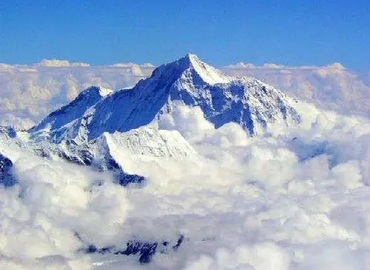
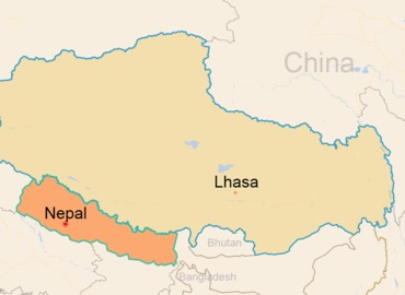
The Himalayas, which lie on the southern edge of the Tibetan plateau, are located in China Tibet, Pakistan, India, Nepal, and Bhutan. The main parts are located on the border of China and Nepal. It starts from the Nanga Parbat Peak in the northwest of the Tibetan plateau in the west and reaches Namcha Barwa Peak at the sharp bend of the Yarlung Tsangpo River in the east, with a total length of 2,400 kilometers and a width of 200 ~ 350 kilometers. The Himalayan mountain range is also the highest in the world. The well-known Mount Everest is the main peak of the Himalayas, with an elevation of 8,844.43 meters, which is the highest peak in the world. In the Tibetan language, the Himalayas are known as the "abode of snow". On earth, besides the South and North Poles, the Himalayas are also called the "third pole" of the world, as it's covered with heavy snow and ice all year round.

Basic Facts about the Himalayas
- Name: the Himalayas
- Sanskrit name: hima ālaya (meaning abode of snow)
- Location: spanning 5 countries(India, Pakistan, Nepal, China and Bhutan )
- Width: 200 ~ 350 km (124 ~ 217 miles)
- Altitude: above 7,000-8,000 m on average
- Total length: 2,400 km (1,500 miles)
- Main peak: Mount Everest (Qomolangma)
- Latitude and longitude: 27° 59' N, 86° 56' E.
Origin of Himalayans
Since the birth of the earth, the crustal plates have kept separating and merging. Each convergence creates scars on the earth - mountains. About 65 million years ago, the Tibetan Plateau was still at the bottom of the Neo-Tethys Ocean, the second-largest ocean in the world at that time. Around 59 million years ago, the Indo-Australian Plate crashed into the southern edge of Eurasia after a journey of 30 million years and 3,700 kilometers. This is the largest plate tectonic movement in the past 200 million years - the "Himalayan Orogeny". The two plates refused to give in to each other, and the 1,000-kilometer-wide rock was squeezed to just over 200 kilometers wide, causing the Himalayas to rise from the ground and form the world's most majestic mountain range. To this day, the Indian Plate is still pressing against the Eurasian continent at a rate of more than 5cm per year, and the Himalayas are still rising, trying to maintain the honor of being the highest mountain range on earth.
The Climate of the Himalayas
As a large climate boundary, the Himalayas have a decisive influence on the Tibetan Plateau to the north, the Central Asian Highlands and the Indian subcontinent to the south. The rolling Himalayan peaks block cold air from Central Asia and moist air from the Indian Ocean. Thus, the Southern slope (Nepal side) of the Himalayas has abundant rainfall and vegetation, while the Northern slope (Tibet side) has less rainfall and sparse vegetation, forming a striking contrast. With the increase in mountain height, the natural scene of the alpine area also changes constantly, forming a distinct vertical natural zone. On the Northern slope, it’s a plateau mountain climate with year-round snow, short sunshine time and cold. On the South slope, it’s a subtropical monsoon climate with warm and humid, long hours of sunshine, and adequate rainfall.
The Topography of the Himalayas
The topography of the Himalayas is characterized by a gentle Northern Slope and a steep Southern Slope. The South Slope is 6,000 ~ 7,000 meters above the Ganges River and Indian Plain, forming a huge natural barrier to prevent the southwest monsoon from the Indian Ocean. Due to the interception of the mountains, the humid and warm southwest monsoon brings abundant precipitation to the South Slope, which makes the snow line on the South Slope lower. Meanwhile, the mountain interceptions cause less rainfall, higher snow lines and sparse vegetation on the North Slope, which forms a sharp contrast with the South Slope.
With the increase in mountain height, the natural scene of alpine areas also changes constantly, forming an obvious vertical natural belt, which can be divided into three zones from south to north. The south zone is the Piedmont hilly belt, which is about 700 ~ 1,000 meters above sea level. The middle zone is the little Himalayan mountain belt with an elevation of about 3,500 ~ 4,000 meters. The northern zone is the great Himalayan mountain belt, which is the main vein of the Himalayas. The northern zone is composed of many high mountain belts, about 50 ~ 60 kilometers wide, with an average altitude of more than 6,000 meters, among which, dozens of peaks are over 7000 meters above sea level, including the highest mountain in the world----Mt. Everest.
Main Peaks of the Himalayas
The top 10 peaks in the world are Mount Everest, Qiaogori, Kanchenjunga, Lhotse, Makalu, Cho Oyu, Dhaulagiri, Manaslu, Nanga Parbat, and Annapurna. Except for Qiaogori( located in the Karakoram Mountains ), another 9 peaks are in the Himalayan mountain range.

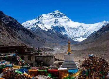
Mount Everest ---- Mount Everest (also known as Qomolangma) is covered with snow and perennial low temperatures all year round. Mount Everest is the main peak of the Himalayas. With an elevation of 8,844.43 meters and an annual growth length of 1.2 centimeters, Mount Everest is the highest peak in the world. There is the world's highest temple Rongbuk Monastery under the mountain in Tibet.
Kanchenjunga ---- Kanchenjunga is at a height of 8,586 meters above sea level, located in the middle of the Himalayas, on the Nepal-Indian border at 88 ° 09 '01 "E, 27 ° 42' 09" N. It is known as the "five great snow treasures", derived from its five summits. The four of its summits are more than 8,450 meters high.
Lhotse---- at 8,516 meters above sea level, Lhotse is the fourth-highest mountain in the world. It is located at 86.9 ° east longitude and 27.9 ° north latitude. Its east side is located in the Tibet Autonomous Region of China, and its west side belongs to Nepal. Lhotse means "the south peak" because it is just 3 kilometers south of Mount Everest, the two mountains separated by a lap, which is known as the "south lap".
Makalu ----Makalu is 8,463 meters above sea level, located in the middle of the Himalayas, 87 ° 06 'east longitude, 27 ° 54' north latitude. It's 24 km from Mount Everest in the northwest. Along the northwest-southeast ridge as the boundary, the northern part belongs to Tibet, China; and the southern part belongs to Nepal. The peaks are covered with thick snow and ice all year round, and there are huge glaciers on the slope and in the valleys.
Cho Oyu ---- With an elevation of 8,201 meters, Cho Oyu is the world's sixth-highest peak. Located on the China-Nepal boundary of 86.6 ° E and 28 ° N, the mountain peak is bounded by the northeast and southwest ridges, with the north in Tingri, Tibet autonomous region and the south in Nepal. Cho Oyu stands in the middle of the Himalayas, 100 kilometers east of the world's highest peak----Mount Everest. Cho Oyu mainly has five ridges, namely, the northwest, northeast, southwest, southeast, and west mountain. The peak is covered by everlasting snow and countless ice.
Dhaulagiri ---- Dhaulagiri is the seventh highest mountain in the world at 8,167 meters above sea level, it is located in Nepal.
Manaslu ---- Manaslu is the eighth-highest mountain in the world at 8,163 meters above sea level. It is located in the Mansiri Himal, part of the Nepalese Himalayas, in the west-central part of Nepal.
Nanga Parbat ----Nanga Parbat is the ninth highest mountain in the world at 8,126 meters above sea level and is located in the Kashmir area.
Annapurna ---- Annapurna is the tenth-highest mountain in the world at 8,091 meters above sea level and is located in Nepal.
Shishapangma ---- Shishapangma located in Nyalam, Shigatse, Tibet autonomous region, is 8,027 meters above sea level. Shishapangma is the only 8,000-meter peak located entirely in China.
Email response within 0.5~24 hours.