
How to Get to Ngari?
- Beatrice
- Last Updated : 04/21/2026
Ngari, is a remote region in western Tibet and the southwest Tibetan Plateau. It is bordered by Shigatse to the Southeast, Nagqu to the East, Xinjiang to the North, India and Nepal to the Southwest. Ngari has a total land area of 345,000 square kilometers, spanning 680km from south to north and 700km from east to west. The landscape of Ngari is full of gorges, peaks, lakes, forests, and volcanoes, making it difficult to develop a good transportation system in this region. However, tourists are able to get to Ngari and see Lake Manasarovar, Mount Kailash and Guge Kingdom through the constructed roads and airport.
Flight to Ngari
There are two to three daily flights between Lhasa Gonggar Airport (LXA) and Ngari Gunsa Airport (NGQ), with a flight time of about 2 hours and 20 minutes. In addition, there is one daily flight between Lhasa Gonggar Airport (LXA) and Purang Airport (APJ), taking approximately 2 hours.
From Ngari Gunsa Airport, it is about 199 km to Darchen, which takes around 2 hours and 47 minutes by road. From Purang Airport, the distance to Darchen is about 92 km, with a driving time of approximately 1 hour and 32 minutes.
By contrast, an overland journey from Lhasa to Darchen takes more than 20 hours, while a combination of flight and road travel reduces the journey to under 10 hours. Darchen is the most popular destination in Ngari, as it serves as the starting point of the Mount Kailash kora.
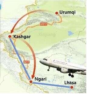
If you are traveling from mainland China to Ngari, you can also travel via Lhasa by flight because there are flights to Lhasa from Chengdu, Beijing, Xian, Chongqing, etc, and many trains from Shanghai, Beijing, Chengdu, Guangzhou, and Chongqing to Lhasa. You can also take a flight from Urumqi Diwopu Airport (URC) to Lhasa with a stopover at Kashgar Airport (KHC). It takes about 4 hours and 35 minutes between Urumqi and Ngari by flight.
Ngari Gunsa Airport
Ngari Gunsa Airport is a dual-purpose airport because it is used by civilians and the military. This airport is 4,274 meters above sea level, which makes it the world’s fourth-highest airport. Its runway is 4,500 meters long and its terminal covers 3,900 square meters area of land. It takes about 3 hours to drive from Gunsa Airport to Mount Kailash, covering a distance of 201km.
Ngari Purang Airport
Ngari Purang Airport is a 4C-class regional airport for both civilian and military use. It is situated at an altitude of 4,250 meters, with a runway length of 4,500 meters and a terminal area of 6,000 square meters. From Purang Airport, it takes around 1.5 hours to reach Mount Kailash by road, covering a distance of about 100 km.
Note: It is advisable not to fly to Ngari directly if you don’t have any plateau-traveling experience. Most people traveling to Tibet for the first time always have high altitude sickness symptoms, so it's better to get to Lhasa first, at 3,650 meters above sea level.
Driving to Ngari
Traveling by road is the most popular way of getting to Ngari. It not only allows travelers to enjoy the amazing views from Lhasa to Ngari, such as the gorges, peaks, forests, lakes, and desert, but also greatly lowers the risk of altitude sickness.
Classic Driving Route: Lhasa – Gyantse – Shigatse – Saga – Darchen
It takes about 3 days to travel from Lhasa to Ngari by following National Highway G318. Start your journey on the first day by driving to Shigatse for a distance of 350km – this journey takes about 8 hours. On this day, you won’t miss the natural beauty of Yamdrok Lake and Karola Glacier as well as the Buddhist sites of Palcho Monastery and Tashilhunpo Monastery. On the second day, travel 8 hours to Saga, where you will enjoy beautiful landscape views such as the high snow peaks, wild plains, and pure Peilkhu Tso Lake on the way. On the third day, you will travel from Saga to Darchen for 7 hours, covering a distance of about 550km. It is a 3-day journey that is tiring and long, but it gives you the opportunity to enjoy the views of western Tibet on the way. Also, tourists can adapt to the high altitude gradually and there are fewer chances of high altitude sickness.
The highlights are to visit Everest Base Camp and Mount Kailash during the tour. There is an 8-hour drive from Shigatse to Everest Base Camp and 6 6-hour drive from Mount Base Camp to Saga the next day. In this way, you need to take one more day to reach Darchen in 7 hours.
√ 14 Days Mt Kailash Kora with Mt Everest Tour
Popular Driving Route: Kathmandu - Gyirong - Zhongba - Darchen
It also takes 3 days to travel from Kathmandu to Ngari by following the National Highway G219 via Gyirong. Start your journey on the first day and drive to Gyirong, which is 168 kilometers and takes 8 hours. There are many mountains and valleys along the way; the terrain on both sides is dangerous, and the road conditions are not very good. On the second day, you will travel through towering mountains, dense forests, waterfalls, and barren, finally get to Zhongba County via Saga, taking 7 hours. On the third day, you can enjoy the sunrise of Zhongba Sand Dunes, Gemma Yangzong Snow Mountain, Maquan River scenery, etc., and then go to Darchen, taking around 4.5 hours.
During the three days, the altitude rises rapidly, starting from Kathmandu(1,400) to Gyirong (2,600), to Zhongba (4,700), and to Darchen(4,560). If possible, we suggest you stay in Gyirong for one more night to adapt to the altitude better. You can visit Gyirong Valley, a collection of snow-capped mountains and forests, reputed as the backyard garden of the Himalayas.
√ 9 Days Kathmandu to Kailash Kathmandu Overland Tour
How to Get around Ngari?
Road transportation is the best way of moving around Ngari. But usually, there's a long driving distance from one spot to another.
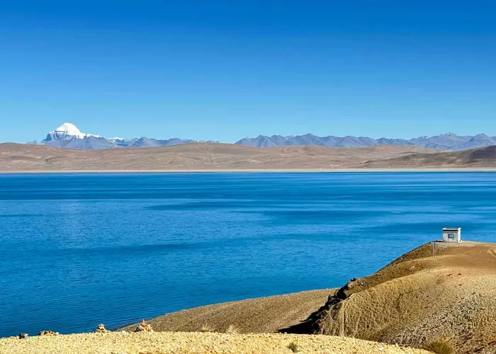
Travel to Manasarovar
If you're traveling from Lhasa to Ngari, you will see Lake Manasarovar first. It's about 40km away from Darchen and takes about 50 minutes. You can visit this lake before/after your pilgrimage to Mount Kailash.
Travel to Kailash
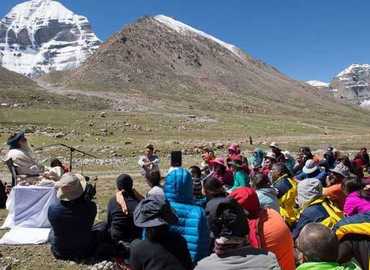
Mount Kailash is a top attraction for tourists visiting Ngari. First, you can drive to Darchen, the starting point of doing the Kora. Darchen also offers food and accommodation. If you are doing a Kora or trekking around Mount Kailash, vehicles will not be available to help you save your energy on the way, but yaks can help you carry your luggage. The road contains a lot of gravel and you need to wear comfortable shoes.

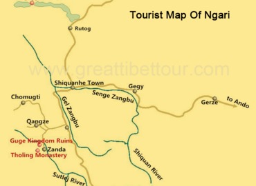
Darchen to the Guge Kingdom
After driving for about 230km on the G219 National Express for 5 hours, you will arrive in Zanda County. Continue driving for another 20km, and you will reach the Guge Kingdom. The journey takes about 30 minutes with good road conditions.
Some Tips for Getting to and Around Ngari
Besides the transportation methods, there is some additional info about getting to and around.
Road Condition
The majority of the roads to and around Ngari are bituminous national highways. These roads are in good condition and bumps are rarely seen, but some sections might freeze during winter because of low temperatures.
Permits
In addition to the compulsory Tibet Travel Permit, you will also need an Alien’s Travel Permit and a Military Permit. Tourists can only obtain these permits by booking with a local Tibet travel agency, which will handle all the necessary arrangements. There are many checkpoints along these roads where security personnel will check all your traveling documents.
Food and Accommodation
Cars often stop at restaurants along these roads during lunchtime, allowing travelers to have a meal. These restaurants offer Sichuan cuisine and some Chinese food, which you may not like, but they will definitely replenish your energy. It is a good idea to go with some snacks and food. Most hotel accommodation in Ngari is very basic.
Conclusion
Although its remote location and high altitude pose challenges, Ngari offers rugged beauty to adventurous travelers. Whether you choose to fly or take a scenic drive, there are pros and cons. Remember to secure the necessary permits to make your trip both smooth and enjoyable.
Email response within 0.5~24 hours.
Typically Asked Questions from Our Clients
kala***
we are planning to go kora mount kailash and also visit EBC.
We will take flight to Lhasa and stay 2 days in Lhasa and take flight to ALI KUNSHA airport.
Can you arrange us all the permit and on road travelling to Darchen and EBC.
Return to Ali Kunsha Airport.
we have 2 option
1. 2 person only
2. 4 person
Hopely early Aug 2026 or end of July 2026
Dear Kala***,
We can arrange the Lhasa EBC Mt.Kailash tour for you in early August. Please kindly note that it usually takes one month to apply for the Tibet Travel Permit.
I would recommend traveling to Darchen by land rather than flying to Ngari Kunsha Airport, so that you can visit EBC on the way. We can arrange for all the permits in Tibet and on-road travel to Darchen and EBC.
After the Kora, you can choose to fly back to Lhasa via Kunsha Airport or Pulang Airport. Please kindly note that the weather is changeable in the Ngari region, so there's a risk that the flight between Ngari and Lhasa would be canceled.
Oliv***
Hallo. I’m currently in Kyrgyzstan and wondering if it would be possible to go from Kashgar to Tibet and end in Nepal?
Dear Oliv****,
You can fly from Kashgar to Lhasa then we will arrange an overland tour for you from Lhasa to Nepal.