Cho Oyu Mountain
- Eric
- Last Updated : 03/29/2026
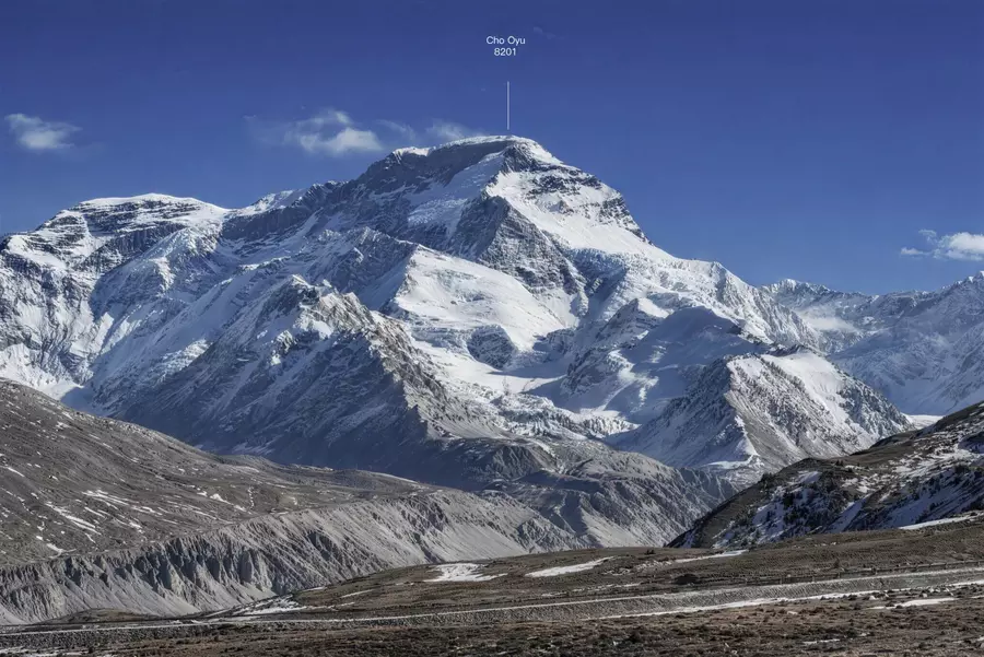
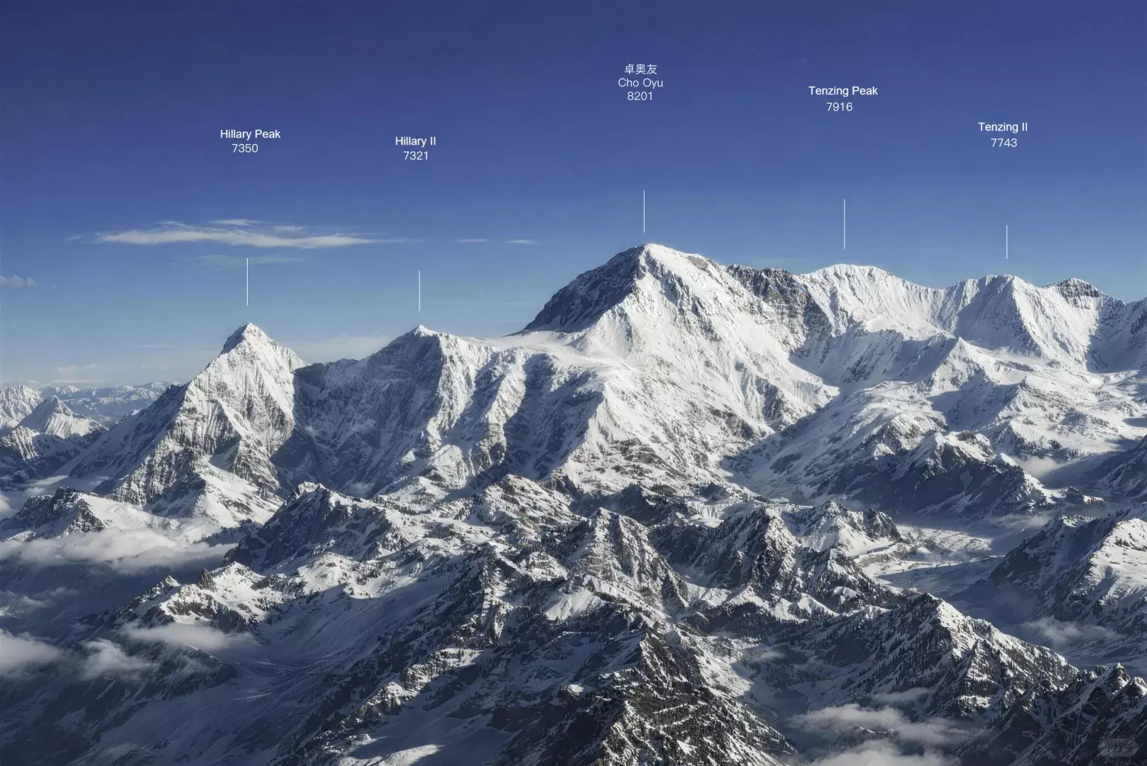
Cho Oyu, the world’s sixth-highest peak at 8,201 meters, lies on the border of Tibet, China, and Nepal, about 28 km from Mount Everest. Its Tibetan name, “Turquoise Goddess,” comes from the icy blue glow of its summit under certain light. Compared with Everest, Cho Oyu features more open terrain and a stable northwest ridge, making it a popular first 8,000-meter peak for climbers seeking both challenge and accessibility.
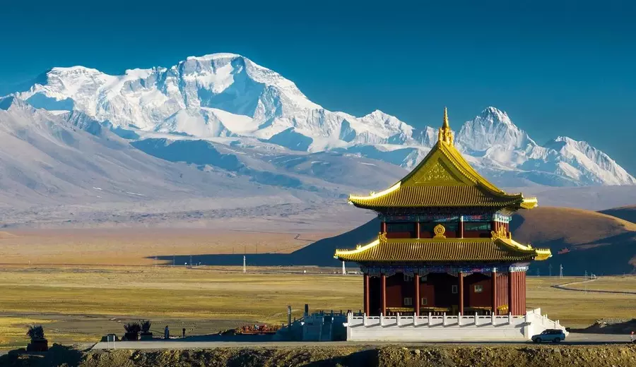
From the Tibetan side, vehicles can reach the base camp directly. Along the way, distant views of the continuous snow ridgelines of the Gyachung Kang range unfold, often glowing with soft golden tones in the early morning light. As the route gradually enters the Cho Oyu region, the landscape becomes increasingly varied, with high-altitude scenery adding depth to the journey. For travelers seeking close contact with the Himalayas and who have some high-altitude experience, this area offers a well-balanced combination of accessibility and challenge.
Content Preview
Cho Oyu at a Glance
• Elevation: 8,201 m (world’s 6th highest peak)
• Location: Himalayas, on the border of Tibet and Nepal, about 28 km from Mount Everest
• Meaning of Name: “Turquoise Goddess” in Tibetan
• Range: Mahalangur Himal
• First Ascent: 1954 by Herbert Tichy, Joseph Jöchler and Pasang Dawa Lama
• Standard Route: Northwest Ridge (from Tibet side)
• Notable Fact: One of the most climbed 8000m peaks
Geography & Mountain Structure
Cho Oyu forms part of the Mahalangur Himal range and straddles the border of Tibet and Nepal. The northern side lies in Tingri County, Shigatse, Tibet, while the southern slopes extend into Nepal’s Solu-Khumbu region, home to generations of Sherpa communities. Tingri serves as a key gateway to Cho Oyu and the northern slopes of Everest. To the south, the historic Nangpa La Pass leads into Khumbu, a traditional trade corridor that once connected Tibet with the southern Himalayas.
The mountain features multiple ridges. The northwest ridge from Tibet is the most commonly used route, with relatively gentle terrain and a stable glacier platform. In contrast, the southern slopes toward Nepal are steeper and technically demanding, remaining covered by snow and glaciers year-round. Glaciers, glacial lakes, and permafrost terrain create a classic high-Himalayan landscape, offering travelers a rich visual experience.
How to Get to Mount Cho Oyu?
Mount Cho Oyu has two main climbing routes: the North Ridge in Tibet and the South Ridge in Nepal.
1. North side, Tibet (Main route)
Most climbers and high-altitude travelers choose this route. The path follows the northwest ridge from Tibet. The slope is gentle, and it requires relatively low technical skills.
- Starting point: Lhasa → Tingri → North Base Camp (4,959 m)
- Advantages: A well-established route with good logistics support, suitable for climbers with some high-altitude experience
- Notes: A Tibet permit is needed. The climb must be organized by a licensed mountaineering operator
2. South side, Nepal (Non-standard route)
This route follows the southwest ridge, with steep terrain and high technical difficulty. Logistics are more complex compared to the north side, and regular commercial climbs are not open.
- Suitable for: Top climbers with rich 8,000-meter experience
- Not suitable for: Inexperienced climbers or first-time high-altitude climbers
History of Climbing Cho Oyu
Mount Cho Oyu was first climbed in 1954 by Austrian climbers Herbert Tichy, Joseph Jöchler, and Sherpa guide Pasang Dawa Lama. They reached the summit without using supplemental oxygen. This achievement challenged the common belief at the time that peaks above 8,000 meters required oxygen to climb.
In the 1980s, the first female climbers reached the summit, creating an important milestone for women in high-altitude mountaineering. After that, many climbing routes on Cho Oyu were explored. The northwest ridge became the main route. The slope is gentle and the technical difficulty is lower. For this reason, it has long been seen as an ideal peak for climbers preparing to climb 8,000-meter mountains.
Today, Cho Oyu draws climbers from around the world. Its stable routes and clear snow lines keep Cho Oyu popular among 8,000-meter peaks.
Climbing Cho Oyu and Its Difficulty
Compared with the other 13 mountains over 8,000 meters, Cho Oyu is relatively easier to climb. It requires lower technical skills to reach the summit. For this reason, it has the second-highest number of climbers among all 8,000-meter peaks, after Mount Everest. Every year, many climbers with high-altitude experience come to challenge it. However, the high-altitude environment still brings extreme lack of oxygen, severe cold, and strong winds, which are serious challenges.
The main risks include altitude sickness (acute mountain sickness, high-altitude cerebral edema, and pulmonary edema), avalanches (especially between C2 and C3), frostbite, and sudden blizzards. Climbers are advised to have solid ice and snow climbing experience and at least one climb on a 6,000–7,000 meter mountain. Most commercial teams provide guides and supplemental oxygen throughout the climb.
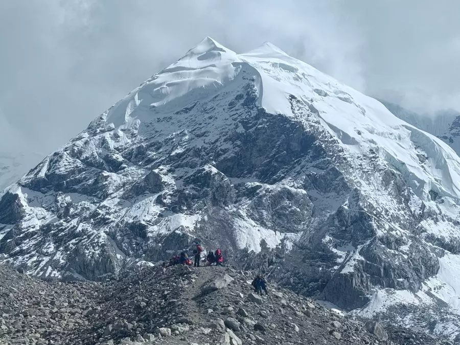
During the climb, climbers face typical high-altitude challenges such as low oxygen, cold, and physical exhaustion. Icefall areas, steep slopes, and high-altitude plateaus are the main difficulties. Climbers need skills to prevent cramps, use oxygen properly, and adapt to high altitude. Although the northwest ridge is relatively gentle, the icefall area between 6,900–7,200 meters is still an important test on the way to the summit.
The summit of Cho Oyu is a large, flat snow platform instead of a sharp pyramid. The mountain mainly consists of northwest, northeast, southwest, southeast, and west ridges. The climate is changeable. Winters are dry and windy, and summers are affected by the monsoon, showing a typical continental plateau climate.
Because of its stable routes, clear snow lines, and scenic glacier features, Cho Oyu is an ideal entry-level 8,000-meter peak for climbers. It also gives travelers a chance to experience the Himalayan snow mountains up close.
Best Season for Climbing Cho Oyu
The climate of Cho Oyu is similar to that of Mount Everest. Every year, there are two main seasons: the wind months and the monsoon months.
Wind season: From about late November to early March. The weather is clear but cold and windy.
Monsoon season: From about June to August. There is more snow and rain, which increases climbing risks.
Therefore, the best climbing window periods are spring (April–May) and autumn (September–October).
Spring (April–May): Relatively mild temperatures and stable snow cover make this the preferred season for most commercial mountaineering teams. Mid-to-late May is the golden period for summiting, with light winds and ample weather windows. At this time, the snow ridges and glaciers look particularly spectacular in the sunshine, which is very suitable for taking pictures.
Autumn (September–October): After the monsoon ends, the weather gradually stabilizes. The air is clear, and visibility is good. There are fewer climbing teams, and the summit experience is quieter, but the temperature is slightly lower, so you need to be fully prepared for the cold.
Notes:
- In summer (June–August): There is heavy rain and frequent snow. The risk of avalanches is high, so climbing is not recommended.
- In winter (November–March): There have been successful climbs, but it is extremely cold and windy. Only experienced professional climbers should attempt it.
- Even though it is an entry-level 8,000-meter peak, there are still high-altitude risks. Climbers need proper acclimatization and must obtain permits through official agencies.
- Spring and autumn are the "golden seasons". They not only increase the chance of success but also offer the best time to enjoy snow ridges, glaciers, and highland scenery.
Itinerary & Cost
Climbing Cho Oyu requires a systematic plan due to its 8,201-meter altitude and complex terrain. Below is a reference schedule for the standard north side route (northwest ridge) in Tibet. It is suitable for climbers with high-altitude experience and professional skills.
Itinerary Overview (approx. 40–50 days)
Days 1–5: Lhasa acclimatization
- Arrive in Lhasa (3,650 m), complete entry formalities and climbing permit.
- Begin altitude acclimatization and visit sights such as the Potala Palace.
Days 6–10: Travel to Base Camp
- Drive along the southern Tibet road via Shigatse and Lhatse to Tingri County (4,300 m), adapting to higher altitude along the way.
- Turn onto a simple road, about 40 km to the North Base Camp (BC, 4,959 m).
- Set up camp, organize equipment, conduct safety briefing and acclimatization training.
Days 11–30: Camp setup and high-altitude adaptation
- Establish Advanced Base Camp (ABC, ~5,700 m).
- Camp 1 (C1, ~6,450 m): rocky slope and snow slope, open view.
- Camp 2 (C2, ~7,100 m): snow-covered ridge, big altitude challenge.
- Camp 3 / Summit Camp (C3, ~7,540 m): snow slope camp, prepare for summit.
- Use “climb high, sleep low” method to adapt to high altitude repeatedly.
Days 31–40: Summit attempt and descent
- Start from C3, pass the mixed ice and rock wall at 7,750 m, then climb the snow slope to the summit (~8,201 m).
- After reaching the top, descend to C1 or ABC, then return to Base Camp.
Days 41–50: Dismantle camp and return
- Pack equipment and leave Base Camp.
- Drive back to Lhasa, celebrate, and complete exit formalities.
Route Features
- Difficulty: The northwest ridge is the standard route. The slope is gentle. The terrain is mainly snow and ice. No technical rock climbing is required.
- Main risks: Altitude sickness, avalanches, frostbite, and sudden snowstorms.
- Summit experience: The summit is a wide, open platform. You can see Mt. Everest, Lhotse, and other nearby peaks.
Cost Reference
- Total cost range: approximately $17,000–$42,000
- Content included: full guide, logistical support, camp setup, partial oxygen assistance (depending on team arrangements)
- Not included: personal equipment, international air tickets, insurance and additional personal expenses
- Cost differences mainly depend on:
- Team size and organizational form (private team vs. commercial team)
- Level of service provided (mountain guide, kitchen support, oxygen, etc.)
- Climbing season and weather window
Email response within 0.5~24 hours.