
Lhasa to Kathmandu Riding Tour
- Eric
- Last Updated : 12/03/2025
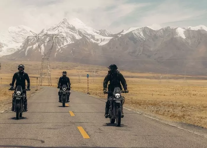
The Lhasa to Kathmandu cycling tour offers adventurers a once-in-a-lifetime journey across the Himalayas, covering over 1,000 kilometers through breathtaking landscapes and high-altitude mountain passes. Before setting out, travelers are advised to stay in Lhasa for at least three days to acclimatize to the high-altitude environment and minimize the risk of altitude sickness, bringing the total trip duration to about 17 days. The journey crosses six major mountain passes and traverses the mighty Himalayas. Along the way, you'll admire the majestic northern face of Mount Everest and explore two of Tibet's most fascinating cities.
You can also do the trip in reverse, cycling from Kathmandu in Nepal to the holy city of Lhasa. This direction usually takes over two weeks, since you’ll need time to acclimatize to the high-altitude conditions upon reaching Tibet.
Route Overview
- Lhasa acclimatization (3 days)
- Lhasa-Gyantse: 262km (3 days)
- Gyantse - Shigatse: 93km (1 day)
- Shigatse-Everest Base Camp: 390km (5 days)
- Everest Base Camp - Nepal border: 353km (4 days)
- Nepal border (Rasuwagadhi) - Kathmandu: 160km (drive 1 day)
What to See?
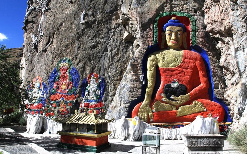
Nietang Buddha
About 20 kilometers southwest of Lhasa, along the Friendship Highway beside the Lhasa River, you’ll first encounter the Nietang Buddha.
Located at the northern foot of Nietang Mountain, this is the largest cliff-carved statue in Tibet. The statue depicts Shakyamuni Buddha in a seated position, 9.83 meters tall and 7.9 meters wide. Magnificently carved, it is regarded as one of the finest examples of Tibetan stone sculpture.
According to legend, the statue was created more than 700 years ago. When Phags-pa, the Imperial Preceptor of the Yuan Dynasty, returned to Sakya Monastery carrying a statue of Shakyamuni from Beijing, the statue requested to remain there, giving rise to this legend of the Nietang Buddha.
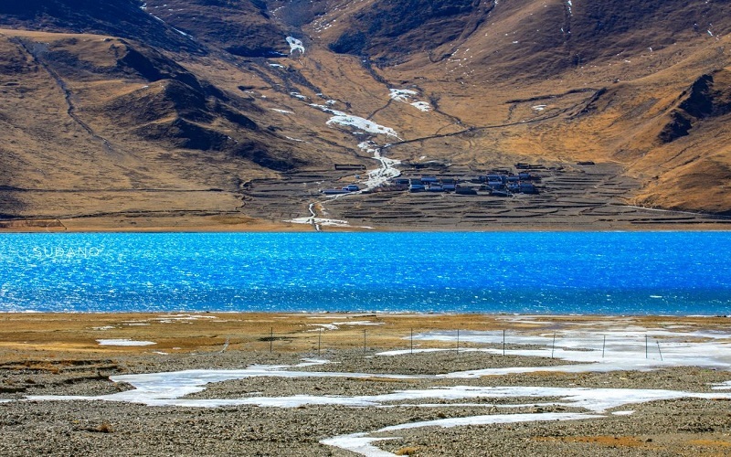
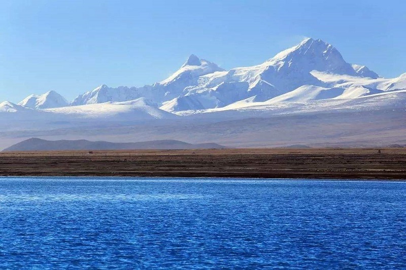
Yamdrok Lake
Next, you'll enter Nagarzê County and cross the Kampala Pass to reach Yamdrok Lake.
In Tibetan, Yamdrok Yumtso means “Swan Lake”, and it is one of the three holy lakes of Tibet. The lake sits at 4,441 meters above sea level, stretching about 130 km east to west and 70 km north to south, with a shoreline of about 250 km and a surface area of 638 square kilometers.
Because of its many branches that resemble coral, the lake is also called “the upper coral lake” in Tibetan. Its turquoise water glistens like a sapphire against the vast plateau landscape.
From Nagarzê to Gyantse, the asphalt road is smooth but undulating, making for a challenging yet rewarding ride.
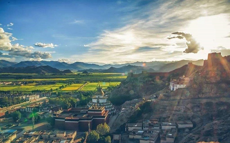
Gyantse
The name Gyantse means“the peak of victory” in Tibetan. The Nyang Chu River flows through the town, which was historically known as Nyang.
In the center of the ancient town stands the Gyantse Dzong, a fortress perched atop a cliff at 4,020 meters. It rises about 125 meters above the plain, dominating the landscape. Nearby, you’ll find Pelkor Chode Monastery, where three major schools of Tibetan Buddhism—Sakya, Kadam, and Gelug—coexist. Its most famous feature is the Great White Bodhi Stupa (Kumbum).
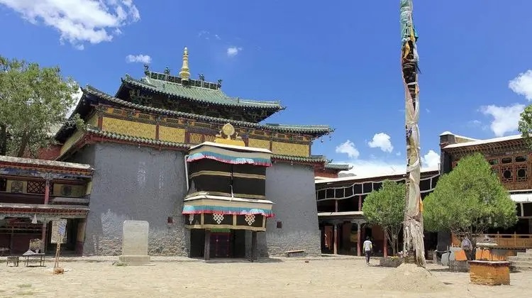
Shalu Monastery
The road from Gyantse to Shigatse is well-paved, and you can visit Shalu Monastery, located about 5 km south of Chhudu town.
Built in 1087 by Chetsun Sherab Jungnay, Shalu Monastery is the main temple of the Shalu Sect (also known as the Buton Sect). The monastery was reconstructed during the Yuan Dynasty with imperial support, reflecting a blend of Tibetan and Chinese architectural styles.
The monastery houses four treasured relics:
- A sandalwood sutra board
- A brass urn for holy water
- A stone basin once used by Chetsun Sherab Jungnay
- A stone tablet carved with the mantra“Om Mani Padme Hum”
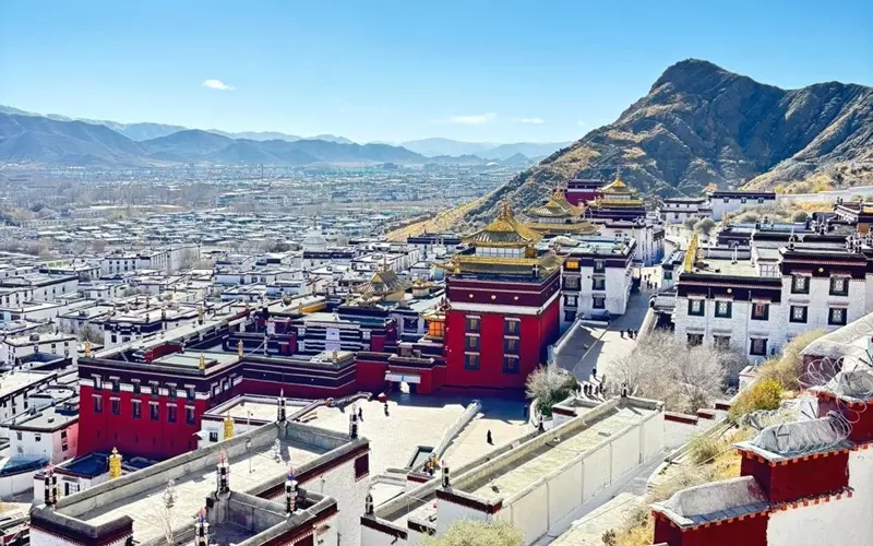
Shigatse & Tashilhunpo Monastery
Shigatse, Tibet's second-largest city, is blessed with rich cultural heritage and natural beauty—sacred mountains and lakes, vast grasslands, and historic monasteries.
The most prominent site here is Tashilhunpo Monastery, the traditional seat of the Panchen Lama and one of the six great monasteries of the Gelugpa School. Built on a hillside, its golden roofs and red walls rise layer upon layer, forming a spectacular spiritual complex often compared to the Potala Palace in Lhasa.
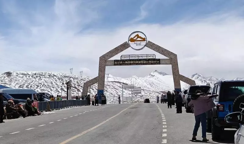
Gyatso-la Mountain Pass
From Shigatse, a two-day ride of 153 km brings you to Lhatse County, followed by another 88 km to New Tingri (Shegar). The highlight of this stretch is crossing the Gyatso-la Pass (5,248 m)—the entrance to Mount Everest National Nature Reserve.
Here, colorful prayer flags flutter against the barren, high-altitude landscape, creating a vivid contrast with the deep blue sky.
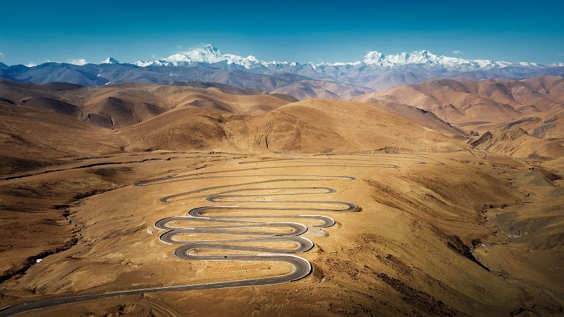
Kya Wu Lha Pass & Everest Base Camp
From New Tingri, it's about 120 km (two days) to Everest Base Camp (EBC). After the ticket gate, the altitude climbs sharply, and the road becomes winding with frequent weather changes.
At Kya Wu Lha Pass (5,210 m), you can enjoy panoramic views of five 8,000-meter peaks—Makalu, Lhotse, Everest, Cho Oyu, and Shishapangma. This viewpoint is famous for its 108 switchbacks, one of the most dramatic mountain roads in the world.
Descending from the pass for about 70 km, you’ll reach Everest Base Camp, one of the best sites for viewing and photographing Mount Everest. Nearby stands Rongbuk Monastery, known as the highest monastery in the world, and the Everest Base Camp Monument at 5,200 meters.
Peikutso Lake
After admiring the golden sunrise on Mount Everest, continue to Peikutso Lake, about 242 km away—a two-day ride.
Peikutso is the largest lake in Shigatse Prefecture, remarkable for its unique mix of saltwater and freshwater zones. Its mirror-like blue surface reflects Mount Shishapangma, creating a tranquil and mesmerizing scene under Tibet’s vast skies.
Gyirong County and the Border
Finally, cycle another 57 km to Gyirong County, where you can stay overnight. From here, it’s just 70 km to the border town of Gyirong.
The first part of this stretch is stark and rugged, but the last 30 km are breathtaking—lush forests of rhododendrons, snow-capped peaks, and winding roads leading down to the Nepalese border. Crossing into Nepal marks the end of this unforgettable cycling adventure from Lhasa to Kathmandu.
Conclusion
Cycling from Lhasa to Kathmandu is more than a test of endurance—it’s a remarkable journey across the Roof of the World. Along this legendary route, you’ll encounter Tibet’s sacred lakes, ancient monasteries, snow-capped peaks, and the warm hospitality of its people. Every climb, every pass, and every breathtaking view deepens your connection to the beauty and spiritual essence of the Himalayas.
Whether you’re an adventure cyclist or a traveler seeking a truly extraordinary experience, the Lhasa–Kathmandu route offers an unforgettable blend of challenge, discovery, and awe.
Email response within 0.5~24 hours.
Typically Asked Questions from Our Clients
hugo***
Hello, next year I'm planning a long cycling trip from Switzerland to Nepal. I'm looking for an agency to help me organize the trip across Tibet from Golmud to the Nepalese border. An agency that could take care of the administrative side (permits).
Do you do this kind of thing?
I heard that we're required to have a car that follows us. Is this correct?
Is it possible to give us a quote for a 12-day trip between Golmud and the Nepalese border? Only for the permits and a car that follows us for logistics. We are independent for sleeping and eating.
Dear Hugo****,
We can arrange Tibet Cycling Tour on Oct 4th 2026 for you.
1. As I know, foreign travelers can't ride bikes from Golmud to Lhasa, but we can arrange the Lhasa-Kathmandu part. You can take a train to Lhasa first.
2. Yes, we must arrange a car and guide to accompany you along the way. Cycling in some places in Tibet is difficult. If you want to ride according to the prescribed itinerary, you may need to take a car for a while.
3. Yes, we can obtain the related permit in Tibet.
Ravi***
We are a group of 4 to 6 cycling enthusiasts interested in undertaking a cycling expedition from Lhasa to Kathmandu in August 2026. We would appreciate it if you could provide us with the following details to help us plan our trip:
1. Detailed Itinerary (day-by-day plan including altitude, accommodation, major landmarks, etc.)
2. Visa Requirements for both Tibet (China) and Nepal
3. Total Cost per Person, including inclusions and exclusions
4. Bicycle Rental Options (including types of bikes available and rental charges)
5. Support Services (like backup vehicle, guides, meals, etc.)
6. Any fitness or experience requirements for participants
Looking forward to your response and hoping to collaborate with your team for this exciting adventure.
Dear Ravi****,
We can arrange the Lhasa to Kathmandu Bike tour for you. I will answer your questions one by one.
1. We need your passort and China Visa to apply for the Tibet Travel Permit. As for the Nepal Visa, you can apply for it at the Tibet-Nepal border.
2. I can attached a bike rent fee. However, I suggest you buy a bike in Lhasa, which may costs RMB600-1000.
3. We will arrange a vehicle for carrying the bike, because sometimes, the weather is not good or the daily itinerary is hard for you.
4. We just arranged the a bike group to EBC, and the cyclists are of all ages, ranging from 20 to 70 years old.
17 Days Lhasa to Kathmandu Bike Tour is the related itinerary. If you agree, I will quote in my next email. If not, I will tweak it until your satisfaction.