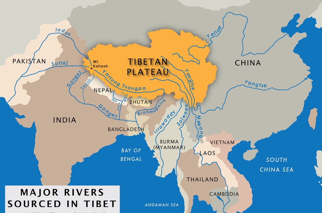
Top 6 Rivers Rising From Tibetan Plateau
- Catherine
- Last Updated : 05/20/2024
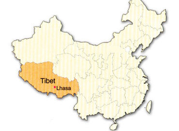
Tibet is the main body of the roof of the world - Tibetan Plateau, with an average elevation of more than 4,000 meters. The Tibetan Plateau is the major resource of big rivers in China and Asia. Incomplete statistics show that there are more than 20 rivers in Tibet with drainage areas greater than 10,000 square kilometers, more than 100 rivers covering an area of greater than 2,000 square kilometers, and thousands of rivers covering an area of more than 100 square kilometers. The source of the famous Rivers in Asia such as the Indus River, Brahmaputra River, Mekong River, and Salween River are all here. It is characterized by an uneven seasonal distribution of runoff, small inter-annual change, low water temperature, abundant flow, low sand content, and good water quality.
The Main Facts About The Tibet Rivers
| Source | Discharge | Length | Basin Area | Country | |
| Yarlung Zangbo River (Brahmaputra River) |
Tibet | Indian Ocean | 2,057km | 246,000km² | China, India |
| Yangtze River (Jinsha River) |
Qinghai | Pacific Ocean | 6,300km | 1,800,000km² | China |
| Yellow River | Qinghai | Pacific Ocean | 5,464km | 752,443km² | China |
| Lancang River (Mekong River) |
Qinghai | Pacific Ocean | 4,880km | 810,000km² | China, Myanmar, Laos, Thailand, Cambodia, Vietnam |
| Nu River (Salween) | Tibet | Indian Ocean | 3,240km | 325,000km² | China, Myanmar, Thailand |
| Shiquan He(Indus River) | Tibet | Indian Ocean | 3,180km | 1,165,500km² | China, India, Pakistan |
Top 6 Rivers Rising From Tibetan Plateau
According to the final destination, the rivers rising from the Tibetan plateau can be divided into four major systems, namely the Pacific Water system (Yangtze River, Yellow River, Lancang River), the Indian Ocean water system (Yarlung Zangbo River, Indus River), the Northern Tibet Continental River system, and the Southern Tibet outflow River system.
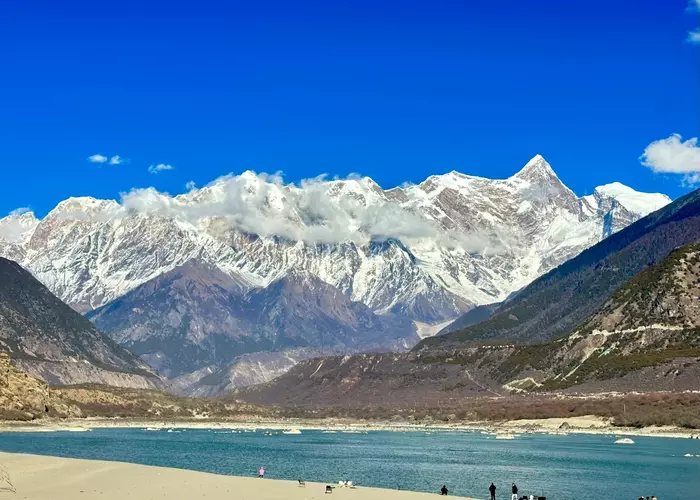
1. Yarlung Zangbo River (Brahmaputra River) - The Highest River In The World

With an average altitude of about 4,500 meters, the Yarlung Zangbo River is the highest river in the world. Yarlung Zangbo River originates from the Jemayangzong Glacier at the northern foothills of the Himalayas in southwest Tibet, which is also the longest plateau river and China and the largest river in Tibet.
The Yarlung Zangbo River in Tibet is 2,057 kilometers long and has a basin area of 246,000 square kilometers, runs across southern Tibet from west to east, and is divided into three sections: upper, middle, and lower reaches. Its upper stream, flowing at an altitude of 4,700 meters, is called the Maquan River. The length is 183 kilometers. With wide river valleys, small slopes of the river bed, and a small amount of water, the Maquan River's water is curved and very clear. The middle reaches of the Yarlung Zangbo River flows from Zhongba County to Meilin County. It's 1,340 kilometers long. However, the river bed altitude drops from 4,600 meters to 2,800 meters. Many main tributaries of the Yarlung Zangbo River, such as Nyang Qu, Lhasa River, and Nyang River are gathered on both sides of the middle reaches. After the river flows through Mirin County, Nyingchi, it bypasses the easternmost Nanga Bawa Peak of the Himalayas and turns southward (the deepest Yarlung Zangbo Grand Canyon in the world) before flowing into India. It is known as the Brahmaputra River in India.
2. Yangtze River (Jinsha River) – The Longest River In Asia & The Largest Economic Belt Of China

Yangtze River, also known as Changjiang River, is the longest river in Asia and the third-longest in the world, with a total length of 6,300 kilometers. The mainstream rises from the glaciers on the south side of the Geladaindong Peak of the Tanggula Mountain in the east of the Tibet Plateau. It passes through Southwest China (Qinghai, Tibet, Yunnan, Sichuan, Chongqing), Central China (Hubei, Hunan, Jiangxi), and East China (Anhui, Jiangsu) and falls into the Eastern China Sea at Shanghai.
The topography of the watershed is long from west to east and narrow from north to south. It is high in the west and low in the east and presents in the shape of three steps: the first step includes the southern Qinghai plateau, the western Sichuan plateau, and the Hengduan Mountain range, with a general altitude of 3,500-5,000 meters; The second step is for the Qinba mountains, Sichuan Basin, Yunnan-Guizhou Plateau, and Hubei Mountainous area, with the general altitude of 500-2,000 meters; The third step consists of the Huaiyang mountains, the Jiangnan hills and the plains of the Middle and lower reaches of the Yangtze River, generally below 500 meters above sea level. Usually, one tells the mainstream of the Yangtze River above Yichang, Hubei is the upper reaches, with a length of 4,504 kilometers and a watershed area of 1 million square kilometers, crossing the first and second steps.
The Jinsha River is an upstream tributary of the Yangtze River and is located in Yunnan province. The famous first bend of the Yangtze River refers to the big bend of the Jinsha River. The mainstream in the middle reaches of the Yangtze River runs from Yichang City in Hubei Province to Hukou County(Jiujiang City) in Jiangxi Province. It is 955 kilometers long and covers a watershed area of 680,000 square kilometers. After Jiujiang City, it is the lower reaches of the Yangtze River. It is 938 kilometers long and has a watershed area of 120,000 square kilometers.
Covering one-fifth of China's land area and supporting one-third of the mainland's population, the Yangtze River economic belt is the largest economic belt in China. The Yangtze River basin is also one of the birthplaces of the Chinese nation, which has long interacted with the Yellow River civilization and other ancient Chinese civilizations and merged into the Chinese civilization. The vastness of the Yangtze River civilization area, a large number of cultural sites, and the high density are the most in the world. The Yangtze Civilization, especially the "rice culture", had a great influence on East Asia and the world.
3. Yellow River - The Second Longest River & The Mother River Of China

The Yellow River is China's second-longest river, after the Yangtze River. Originating from Geda Suqi Peak of Bayan Har Mountains in Yushu, Qinghai Province, it runs across China from west to east. The mainstream is 5,464 kilometers long. It flows through 9 provinces and regions including Qinghai, Sichuan, Gansu, Ningxia, Inner Mongolia, Shaanxi, Shanxi, Henan, and Shandong. Finally, it's injected into the Bohai Sea in Kenli District, Dongying City, Shandong Province. The total area of the river basin is 795,000 square kilometers(including 42,000 square kilometers in the interior flow area).
The upper and middle reaches of the Yellow River are dominated by mountains, while the lower reaches are dominated by plains and hills. From its source to Hekou Town, Inner Mongolia Autonomous Region, is upper reaches, with a length of 3,472 kilometers and a watershed area of 428,000 square kilometers. From Hekou town to Taohuayu(belongs to Zhengzhou, Henan Province)is the middle reaches, with 1,206 kilometers long and a basin area of 344,000 square kilometers. From Taohuayu to Shanghai is the lower reaches, with a river length of 786 kilometers and a watershed area of only 23,000 square kilometers.
The Yellow River traverses China from west to east, with a watershed that is 1,900 kilometers long and 1,100 kilometers wide from north to south. The middle and lower reaches of the Yellow River are the main source of Chinese civilization, and the Chinese call it the "Mother River". The Yellow River produces 1.6 billion tons of sand every year, of which 1.2 billion tons flow into the sea, and the remaining 400 million tons remain in the lower reaches for years, forming an alluvial plain. It's conducive to planting. It is also one of the economic and cultural centers of China. So the Yellow River is of great significance to the history and culture of China.
4. Lancang River (Mekong River) - The Heart And Soul Of Southeast Asia

The Lancang River originates in the northeast of the Tanggula Mountain in Yushu, Qinghai Province, flows southwards through Qinghai, Tibet, and Yunnan provinces of China, Myanmar, Laos, Thailand, and Cambodia, and falls into the South China Sea from Saigon, Vietnam. It is the largest international river in Southeast Asia. The basin covers an area of 164,800 square kilometers and is 2,139 kilometers long. After the Lancang River flows out of the Chinese border in Southern Yunnan Xishuangbanna Dai Autonomous Prefecture, it is called the Mekong River.
More than 60 million people depend on the Mekong River for life. The Mekong River gives them food and water, as well as navigational convenience, and benefits all aspects of their daily lives. This river has the most abundant and diverse fishery resources in the world, second only to the Amazon River in Brazil.
5. Nu River (Salween) - The Core Of The Three Parallel Rivers of Yunnan Protected Areas

The Nu River rises from the glacier at the southern foothills of the Tanggula Mountain in Amdo County, Nagqu City, Tibet Autonomous Region. It flows through Tibet and Yunnan Province, flows into Myanmar, known as the Salween River, and finally flows into the Indian Ocean. The mainstream has a length of 2,013 kilometers and a watershed area of 124,800 square kilometers.
The Nu River, the Lancang, and the Jinsha River (upper Yangtze River) run through the Hengduan Mountains within Yunnan Province and flow hundreds of kilometers in parallel without crossing each other. This natural wonder is known as the Three Parallel Rivers.
This area has a total area of 17,000 square kilometers and is one of the largest world heritage sites in China, namely the Three Parallel Rivers Protection Area. This is the core area of China's biodiversity and is famous for it. There are more than 6,000 plants living in the World Heritage Site, and it is believed that it breeds 25% of the world’s animal species and 50% of China’s animal species. At the same time, it is also known for its cultural diversity, with nearly 300,000 people from 13 ethnic groups living here. The Nu River is currently the only river in China without a hydroelectric dam.
6. Shiquan He (Indus River) - The Largest River In Ngari Prefecture of Tibet

The Shiquan River (also called Sênggê Zangbo) originating from the north of the Holy Mountain Kailash, also near the Lake Mansarovar of the Tibetan plateau, flows out from a cliff like a large open mouth of a male lion. Hence it is named Senge Zangbu in Tibetan, which means the river rising from the mouth of a lion.
The upper reaches of the Shiquan River have a length of 185 kilometers long, from its source to Geji County; the middle reaches are 87 kilometers long, from Geji County to Tashigang; the downstream has a river length of 87 kilometers long, from Tashigang to the border. There are endless prairies, majestic snow mountains, picturesque hills, and dreamy natural landscapes, and it is a paradise for wild animals. The mineral resources, geothermal resources, and solar energy resources are very rich here. Along the river, there are also ancient monuments such as Rirakama, Dingzhongze Pottery Ruins and Tashigang Temple.
After flowing out of the Chinese territory, the Shiquan River is known as the Indus River. It flows through the Kashmir area jointly controlled by China, India, and Pakistan and turns south to run through the whole territory of Pakistan. Finally, it is injected into the Arabian Sea with a total length of 3,180 kilometers and a drainage area of 1,154,900 square kilometers. The Indus River is the main river in Pakistan. The Indus Civilization was one of the first major civilizations in the world to enter agricultural civilization and settle society.
Email response within 0.5~24 hours.