

Everest Base Camp Trek Map
- by Caroline
- Last Updated: 2023-03-25
As a world-recognized trekking paradise, Nepal is home to 8 of 14 world's 8000-meter snow mountains. Surrounded by snow-capped mountains and glaciers, Nepal has developed a number of national parks and numerous treks. Whether you have previous trekking experience or not, this magnificent country of snow-capped mountains has a trek suitable for you.
Among them, the Everest Base Camp Trek(EBC trek for short) in Sagarmatha National Park is the most classic one in the world. In fact, Nepal’s EBC trek refers to not only one route but several routes in the region according to different durations, ranging from 10 days to 3 weeks. Here are three classic Everest Base Camp trek routes as well as maps:
Route 1: Lukla to Everest Base Camp Trekking Map
- Trek Level: Medium - suitable for the trekkers who have less time and are only interested in EBC
- Distance: 59 km
- Duration: 10 days
- Best Time: September to December & March to May
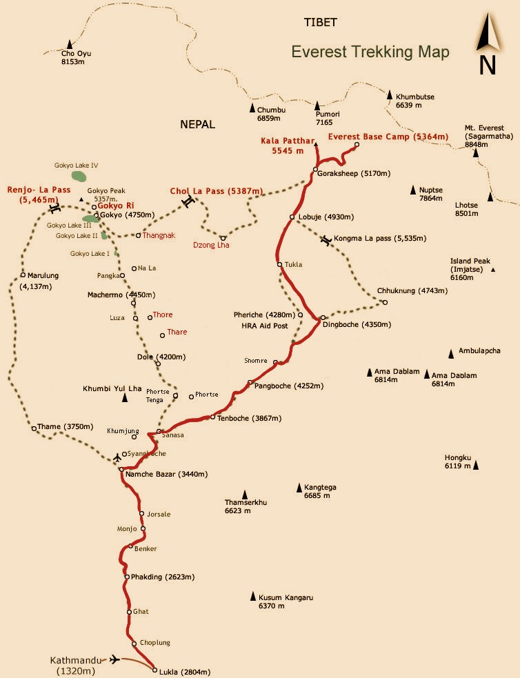
The biggest difficulty of this route is the long duration and high altitude, with big ascends of some individual sections and complicated road conditions.
Trekking Route
- D1 Kathmandu – Lukla (2840 m) – Phakding (2610 m)
- D2 Phakding (2610 m) – Monjo (2840 m) - Namche Bazar (3440 m)
- D3 Namche Bazar (3440 m) - Tengpoche(3860 m)
- D4 Tengpoche (3860 m) - Pangboche(3930 m) – Dinboche (4410 m)
- D5 Dingboche (4410 m) – Lobuche (4910 m)
- D6 Lobuche (4910 m) - Gorap Shep (5140 m) - Kala Patthar (5600 m) - Gorap Shep (5140 m)
- D7 Gorak Shep (5140 m) – EBC (5364 m) – Lobuche (4910 m)
- D8 Lobuche (4910 m) – Pangboche (3930 m)
- D9 Pangboche (3930 m) - Namche Bazar (3440 m)
- D10 Namche Bazar(3440 m) – Phakding (2610 m) – Lukla (2840 m)
Route 2: Everest Base Camp Trekking Map via Gokyo
- Trek Level: Difficult - trekking enthusiasts with certain physical strength
- Distance: 140 km
- Duration: 15 days
- Best time: September to December
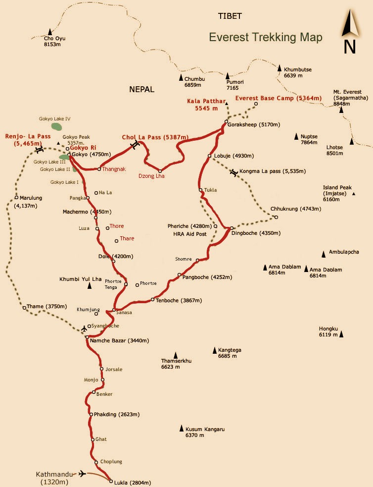
This is not a retrace route. On the trail, you can see alpine valleys, villages, and dozens of snow-capped mountains every day. Among them, there're 3 mountains above 8000 meters - Mount Everest, Lhotse, and Cho Oyu.
Although the distance is far, you will have a break to acclimatize the high elevation in Namche Bazar(3440m) and Dingboche(4410m). The daily trekking time is about 3-6 hours, and the elevation of the accommodation area rises within 500 meters every day to fully adapt to the plateau. As long as there are experienced leaders, tourists without much trekking experience can choose this route with confidence. For trekking enthusiasts who often climb mountains, it can usually be done in about 15 days.
Trekking Route
- D1 Kathmandu – Lukla (2840 m) – Phakding (2610 m)
- D2 Phakding (2610 m) – Monjo (2840 m) - Namche Bazar (3440 m)
- D3 Namche Bazar (3440 m) - Tengpoche(3860 m)
- D4 Tengpoche (3860 m) - Pangboche(3930 m) – Dinboche (4410 m)
- D5 Dingboche (4410 m) – Lobuche (4910 m)
- D6 Lobuche (4910 m) - Gorap Shep (5140 m) - Kala Patthar (5600 m) - Gorap Shep (5140 m)
- D7 Gorak Shep (5140m) – EBC (5364 m) - Gorak Shep (5140 m)
- D8 Gorak Shep (5140 m) – Lobuche (4910) – Dzonghla (4830)
- D9 Dzonghla (4830 m) - Chola Pass (5330)- Dragnag (4700)
- D10 Dragnag (4700 m) – Gokyo (4790 m) - Gokyo Ri (5360 m) – Gokyo (4790 m)
- D11 Gokyo (4790 m) - Thonak Thso (4870 m, 4th lake) - Ngozumba Thso (4990 m, 5th lake) - Gyazumba Thso (5116 m, 6th lake) – Gokyo (4790 m )
- D12 Gokyo (4790 m) - Phortse Tenga (3680 m)
- D13 Phortse Tenga (3680 m) – Namche (3440 m)
- D14 Namche (3440 m) – Lukla (2840 m)
- D15 Lukla (2840 m) – Kathmandu
Route 3: EBC Three Passes Loop Trekking Map
- Trek Level: very difficult - suitable for hikers with high demand for photography and good physical strength
- Distance: 188 km
- Duration: 17days ~ 18 Days
- Best time: September to December
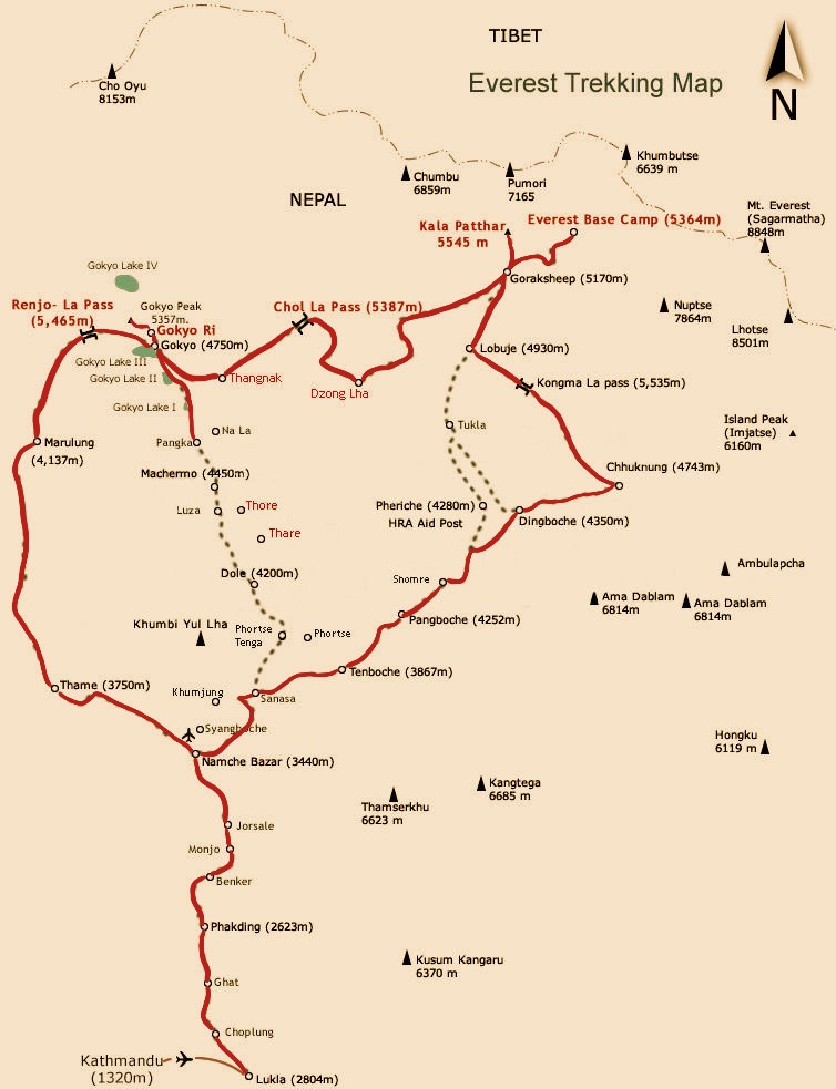
The three main observation decks have different perspectives. On this route, trekkers have a close view of Lhotse at the Chukung Ri Observation Deck in Chukung, Mount Everest at the Kala Pathar Observation Deck in Gorakshep, and Cho Oyu at the Gokyo-Ri Observation Deck in Gokyo. In the first and second glacial lakes of Kongma La Pass, trekkers also see the reflections of Lhotse(8516 m), Nuptse(7861 m), Makalu(8485 m), Baruntse(7129 m), Ama Dablam(6812 m), etc.
In order to reduce the number of repeated routes for tourists and save trekking time, this Everest trekking route needs to cross the three major passes of Kongma La, Cho La and Renjo La, thus forming an EBC super large loop. The trekking time is about 18 days.
From the beginning of this journey, the snow-capped mountains will surround you. Walking among the snow-capped mountains, you may feel the greatness and smallness of nature and man. For those of you who love the Himalayas and snow mountains, you will obtain full of happiness.
Compared with the small loop, this route is more difficult, especially when crossing the Kongma La Pass, with the highest elevation among the three passes. After climbing over the pass and rapid descending, trekkers need to cross the Khumbu Glacier, with no supplies along the way. So people who do not have enough trekking experience are prone to altitude sickness or physical exhaustion. Please be careful to register!
Trekking Route
- D1 Kathmandu(1300m)-Lukla(2840m)-Phakding(2610m)–Monjo(2835m)
- D2 Monjo(2835m)-Namche(3440m)
- D3 Namche(3440m)-Tengboche(3860m)-Pangboche(3930m)
- D4 Pangboche(3930m)-Ama Dablam Base Camp(4600m)- Dingboche(4410m)
- D5 Dingboche(4410m) - Chhukung(4730m)
- D6 Chhukung(4730m)-Chhukung Ri(5546m)- Chhukung(4730m)
- D7 Chhukung(4730m) -Kongma La Pass(5535m) -Chhukung(4730m) -Lobuche(4910m)
- D8 Lobuche(4910m)- Gorak Shep(5140m)- Kala Patthar(5545m)- Gorak Shep(5140m)
- D9 Gorak Shep(5140m)- Everest BaseCamp(5364m) -Gorak Shep(5140m)
- D10 Gorak Shep(5140m)-- Kala Patthar(5545m)- Gorak Shep(5140m)
- D11 Gorak Shep(5140m)- Lobuche(4910m)-Dzonglha(4830m)
- D12 Dzonglha(4830m)-Cho La Pass(5420m)-Gokyo(4790m)
- D13 Gokyo(4790 m) - Thonak Thso(4th Lake 4870 m) - NgozumbaThso(5th Lake, 4990 m) - Gyazumba Thso(6th Lake, 5116 m)- Gokyo(4790 m)
- D14 Gokyo(4790m)-Gokyo Ri(5360m)-Gokyo(4790m)
- D15 Gokyo(4790m)-Renjo La Pass(5345m)-Lumde(4380m)-Thame(3800m)
- D16 Thame(3800m)-Namche(3440m)-Lukla(2840m)
- D17 Lukla(2840m)-Kathmandu(1300m)
Related Articles
-
Where is Nepal Located?
Located on the southern slopes of the Himalayans, Nepal is a landlocked country in South Asia, in eastern Eurasia, and on the west coast of the Pacific Ocean. -
Nepal Tibet Map
Nepal and Tibet are located on the south and north side of the Himalayas. Here're practical travel maps of the world's two top tourist destinations. -
Nepal Bhutan Tibet Tour Tips
Nepal Bhutan Tibet tour is a transnational journey. Before this special tour, travelers need to know some tips about permits and visas and attractions. -
How to Plan a Nepal Tibet Bhutan Tour?
Here are some tips for planning a wonderful Nepal Tibet Bhutan tour including regional overviews, required permits and visas, travel routes... -
Lukla: World's Most Dangerous Airport and Gateway to Mt.Everest
Lukla Airport(Tenzing-Hillary Airport) is located in Lukla in eastern Nepal. It is the only gateway from Kathmandu to Mount Everest. -
Top 10 Tourist Places to Visit in Nepal
Nepal is a beautiful country. Hinduism, Buddhism, ancient palaces, as well as rich and colorful natural landscape, constitute its unique tourism resources. -
Grand Festivals and Holidays of Nepal
Festivals of Nepal are an important part of Nepalese traditional culture. Most Nepali festivals originate from the worship of various gods. -
Dashain Festival in Nepal
Dashain is the largest and longest festival in Nepal. It means tenth in Nepali. It is to commemorate the victory of Goddess Durga over Buffalo demon. -
Tihar in Nepal
Tihar, also known as Deepawali or Diwali, is the most beautiful festival in Nepal for driving away darkness with light and defeating evil with goodness. -
Hartalika Teej Festival
Hartalika Teej is a traditional festival celebrated by Hindu women. During the festival, married women would fast and pray for longevity for their husbands. -
Things to Know Before Visiting Nepal
Before you visit Nepal, it is necessary to know some Nepal travel tips including how to get to Nepal, cuisines, things to do, best time to go, etc.
Email response within 0.5~24 hours.
Typically Asked Questions from Our Clients
Asked by Bija***
Does this Everest Base Camp Trek is of Nepal Side or Tibet Side and how much does it cost for the trip
Dear Bija****,
Thank you for sending us an inquiry!
All the three routes of Everest Base Camp Trek are in Nepal.
We have a 10-day trek, a 15-day trek, and a 17-day trek, which route do you prefer?
Before I quote you, could you please kindly let me know the following info?
1. What's your nationality?
2. When are you going to have Tibet tour? Different season, different cost.
3. How many people in your group?
Please let me know without hesitation if you have any further questions or doubts.
Looking forward to hearing from you!
Asked by Ssur***
i would like to come by my bike from chhattisgarh raipur to the nearrest point to namche bazar
Dear Ssur****,
Thank you for sending us an inquiry!
There is no road access from Chhattisgarh Raipur to the nearest point to Namche Bazar. You can trek (4-5 days or fly 35 mins ) to Lukla and trek to Namche Bazar. We can arrange the trek tour for you.
Please let me know without hesitation if you have any further questions or doubts.
Looking forward to hearing from you!
Asked by Moha***
me and my two grown up daughters are interested to do the trek to mount everest base camp in March 2024. Is that the right time to do so ? If not what earliest date to that do you suggest?
Dear Moh****,
Usually, Tibet will close during February and March due to the Tibetan new year. The earliest time to visit Tibet is from April 1, but to ensure you get your Tibet travel permit, I suggest you come after 10 April.
To visit Everest Base Camp, from the middle of April to the middle of May is the best time, since the adventure team also choose this period to climb Mt.Everest, due to the good weather and much better transparency. Here's 8 Days Lhasa to Everest Base Camp Group Tour for you. Please let me know your idea.